Felisa Rincón de Gautier was the first woman to be elected Mayor of a capital city in the Americas.
On the Día de los Reyes (Three Kings Day), she would bring gifts and treats to the poor and needy children. In 1952, 1953 and 1954, she had plane loads of snow delivered to San Juan so that the children who had never seen or played in snow would be able to do so.
In the early 20th Century, there was no welfare on the island; no social department to provide money or clothing or food for the poor, but no jibaro would let another jibaro starve. The jibaros were a people steeped in tradition, the noblest of which was their hospitality, and Rincón de Gautier lived that tradition to the fullest. (Wikipedia)
Gerald Park Beach on Lake Wangumbaug Coventry, CT
by TheKnowOwl | February 3, 2021 | Connecticut, Coventry | 0 Comments
Historic Beauty of Connecticut’s Merritt Parkway Bridges
by TheKnowOwl | May 10, 2019 | Connecticut | 0 Comments
The Merritt Parkway was the first divided-lane, limited-access highway in Connecticut.
Vintage hand-colored map of Connecticut from 1857
by TheKnowOwl | October 7, 2017 | Connecticut | 0 Comments
This beautiful hand drawn map of Connecticut was created in 1857 by Laura Roys, a student who attended Hartford Female Seminary, an all-female academy in Hartford, Connecticut. The map is beautifully colored, with shades of blue, orange, red, pink, yellow, and violet adorning the border of each city and town.
Beautifully detailed map of Wallingford, CT from 1905
by TheKnowOwl | July 6, 2017 | Connecticut | 0 Comments
Wallingford, Connecticut in the 19th century.
Historic map of Stratford, Connecticut from 1882
by TheKnowOwl | June 13, 2017 | Connecticut | 0 Comments
Historic bird’s eye view of Stratford, Connecticut from 1882
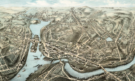
Beautifully restored map of New London, CT from 1876
by TheKnowOwl | June 8, 2017 | Connecticut | 0 Comments
Bird’s eye view of New London, Connecticut in 1876
Beautifully restored map of Ansonia, Connecticut from 1921
by TheKnowOwl | June 2, 2017 | Connecticut | 0 Comments
Old map showing an aerial view of Ansonia, Connecticut from 1921
10 amazing old pictures reveal forgotten history of Hartford, CT
by TheKnowOwl | May 27, 2017 | Connecticut | 0 Comments
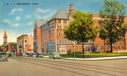
Vintage postcard of the YMCA in Bridgeport, CT from the 1950’s
by TheKnowOwl | May 21, 2017 | Bridgeport, Connecticut | 0 Comments
Vintage Picture of the Chicken Roost in Bridgeport from the 1950’s
by TheKnowOwl | May 21, 2017 | Bridgeport, Connecticut | 0 Comments
The Chicken Roost was a restaurant in Bridgeport, CT that was famous for its “As You Like It” southern fried chicken.
12 vintage postcards of UConn from the 1950’s
by TheKnowOwl | May 18, 2017 | Connecticut | 0 Comments
The University of Connecticut began its history in 1880, when two brothers…
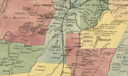
9 beautiful old pictures of Berlin Turnpike landmarks
by TheKnowOwl | May 18, 2017 | Connecticut | 0 Comments
9 historic images reveal the colorful history of Ansonia, CT
by TheKnowOwl | May 18, 2017 | Connecticut | 0 Comments
Ansonia is a city in New Haven County, Connecticut that was first settled by…
Vintage images of Lake Compounce in the 1950’s
by TheKnowOwl | May 15, 2017 | Connecticut | 0 Comments
Lake Compounce, located in Bristol and Southington, CT, is America’s oldest…
24 amazing old images of New Haven’s hidden beauty
by TheKnowOwl | May 11, 2017 | Connecticut | 0 Comments
New Haven is the second largest city in Connecticut. The city was founded in…
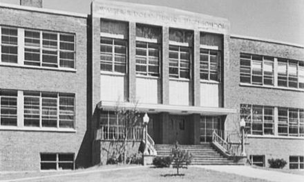
19 historic pictures of Stamford’s Dolan Middle School
by TheKnowOwl | May 11, 2017 | Connecticut | 0 Comments
Generations of Stamford, Connecticut residents have attended Dolan Middle…
14 beautiful old pictures reveal lost grandeur of Bridgeport, CT
by TheKnowOwl | May 8, 2017 | Connecticut | 0 Comments
Bridgeport is a seaport city in the U.S. state of Connecticut. It is the largest city in the…
Stunning vintage map of New Milford, CT from 1882
by TheKnowOwl | April 19, 2017 | Connecticut | 0 Comments
This vintage map shows New Milford, Connecticut as it looked in 1882.
Beautiful vintage map of Forestville, CT from 1880
by TheKnowOwl | April 16, 2017 | Connecticut | 0 Comments
This old map shows the Forestville section of what is now known as Bristol, Connecticut.
Beautifully restored map of Norwich, CT from 1876
by TheKnowOwl | April 14, 2017 | Connecticut | 0 Comments
This old map shows Norwich, Connecticut as it looked in 1876.